Modern technologies reveal the secrets of steelworks from the Viking Age and the Middle Ages in all the communes of Valdres. Valdres is known for its extensive iron mining during the Viking Age and Middle Ages, known as Valdresjern. In the areas where archaeologists made records, metallurgical pits are densely located.
However, most of the forest areas of Valdres have not been surveyed and therefore the cultural monuments are not included on the maps.
This is of course disadvantageous. When cultural monuments are not visible on the map, local communities lose the source of knowledge about their history. There is also a risk of damaging or destroying these cultural monuments, for example when cutting down trees.
To remedy this, Kulturarv at the Cultural Institute of the Innlandet Region carried out activities. In 2023, mapping of cultural monuments in the forest areas of the six communes of Valdres was carried out using LiDAR technology.
The work was done from the office. How was this possible?
Registration from the office using LiDAR technology
Modern technology was very useful in the work: most of the interiors are laser scanned (LiDAR) from an aircraft. On this basis, accurate and very detailed digital terrain models were created. Here you can see a lot of visible cultural heritage. Many of them are so easy to recognize on a computer screen that we can register them directly in Askeladden. So we don't have to waste time visiting them in the field first.
Work began last year to include these visible cultural monuments in Askeladden County. Work began in Midt-Gudbrandsdalen and over a thousand objects were reported here.
Using LiDAR, 8 cultural monuments were found in Valdres
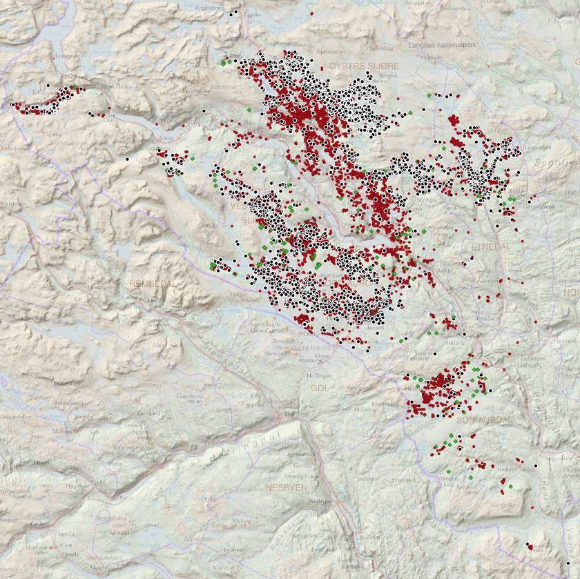
This year, cartographic work moved to Valdres, where over 8 previously unknown cultural monuments were found on LiDAR maps. Most of these are iron mining operations and coal mines linked to the large iron production in Valdres during the Viking Age and Middle Ages.
For large parts of Valdres, LiDAR images proved very useful. In fact, three times as many iron mining and coal mines were found than previously thought. In addition, it provided a more complete picture of where iron production actually took place, not just where archaeologists were located.
Cultural heritage is on the map – maybe on your property?
As a result of the registration work carried out by the Innlandet council, landowners in Valdres will be able to see that at the end of 2023 and in 2024, new protected cultural heritage designations will appear on the map on their properties.
Cultural heritage is protected even if it has not been previously inscribed on a map. All cultural heritage older than 1537, i.e. from the Middle Ages and earlier, is automatically protected under under the Act about cultural heritage.
To help landowners and contractors
This will hopefully be helpful, for example by preventing landowners or forestry contractors from accidentally coming across a protected cultural heritage site while working.
The search for cultural memory
You can independently search for cultural heritage in the place where you live using Cultural heritage search engines. Here you will find all the cultural heritage included in the Askeladden national cultural heritage database.
Like us on Facebook and share our post with others
Source: fylke Innlandet
Photo: Kulturarv, Innlandet fylkeskommune/image of iron mining sites (black dot) and coal mines (red dot) after LiDAR work in Valdres.
Also read: Arrest in a car theft case
